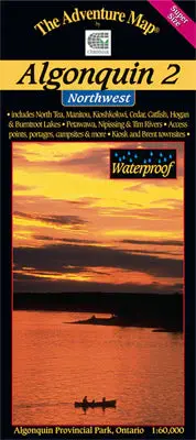

Description
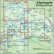
Our detailed topographic map & guide to the more remote northwest quadrant of Algonquin Provincial Park, Ontario. Stretching from Kawawaymog Lake outside the west park boundary all the way past Brent Access Point on Cedar Lake, it overlaps the north edge of our Algonquin 1-Corridor North guide and the west edge of our Algonquin 4 – North Central guide (see our Algonquin Area Map Locator Guide on this page for an illustration of how the series fits together).
In addition to extraordinary terrain and vegetation detail, this map features campsite, portages, access points, hiking trails, facilities like parking, campgrounds, telephones, historic sites and other attractions. And, as with all Adventure Maps®, the back side is covered with text, colour photos and graphics detailing the natural and human history of the area along with suggested routes, safety tips, contact info and much more. We’ve even included a star chart and moon map so you’ll have something to do at night!
As with other Algonquin maps in our series this one has quickly become the standard for on-the-water navigation. We update it regularly, and it is completely waterproof (in a pinch you can use it as rain hat!)
_____
Overlaps with Algonquin 1 – Corridor North, Algonquin 3 – Corridor South, and Algonquin 4 – North Central. Also consider our smaller-size but larger-scale close-up map guides to popular sections of Algonquin Park – Canoe Lake & Area, Opeongo Lake & Area, Oxtongue River & Ragged Falls, Barron-Achray Area and Bonnechere River.

Reviews
There are no reviews yet.